Your phone never sends a thing to the satellites. It only listens. So how does it end up as one blue dot on a map?
Try it yourself in GPS Lab: drag satellites into view and watch their timed signals shrink your position to a single point.
How does a delay become a distance?
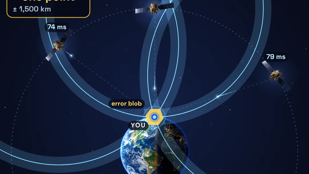
Each satellite broadcasts the time from its atomic clock. Your phone notes when the signal arrives. The delay gives the distance, d = c × Δt, where c is the speed of light, 299,792 kilometers per second.
Straight overhead, a satellite about 20,200 kilometers up is roughly 0.067 seconds away, or 67 milliseconds. A satellite near the horizon is about 25,800 kilometers away, which takes about 86 milliseconds. The signal takes about seven hundredths of a second to cover twenty thousand kilometers.
Why does one satellite leave you on a sphere?
Your distance from one satellite puts you on a sphere around it. In the model’s flat slice through Earth’s center, that sphere is a circle. Earth’s radius is 6,371 kilometers, and GPS satellites orbit about 20,200 kilometers up, so the orbit circle has a radius of 26,571 kilometers.
Earth, the orbit and every distance are drawn to scale in the model. The satellite pictures are not.
Why does a fourth satellite fix the clock?
The phone measures every delay with its own cheap quartz clock. If that clock is off, every distance is off by the same amount. The film’s phone clock starts 5 milliseconds off, which is illustrative.
In three dimensions there are four unknowns: x, y, z and the clock error. Two spheres meet in a circle, and three meet in two points, one of them far out in space, which is ruled out. The fourth satellite pins down the clock. A microsecond of clock error is 299.8 meters of distance, which is where “300 meters” comes from.
Predict first, then try
Before you drag, predict how many satellites your phone needs to fix a position and its own clock error. Count the satellites as you bring them into view in GPS Lab. Then check your count against the yellow blob, where all the bands overlap.
Explain to yourself why a phone that is off by a millionth of a second would be about 300 meters out, even if every satellite is exactly right.
What does the model leave out?
The model’s tag reads “2D slice of a 3D fix.” In a flat slice, three circles could already solve the clock, so the slice stands in for the 3D count rather than proving it. The model also leaves out:
- Atmosphere. Signal delays in the ionosphere and troposphere are not modeled.
- Satellite errors. Orbit and clock errors, corrected with broadcast data, are not modeled. Satellite clocks are also set to tick slower before launch, because in orbit they gain about 38 microseconds a day.
- Geometry and noise. How the satellites’ spread in the sky multiplies errors, reflections off buildings, and receiver noise are not modeled.
- The map. The map on the phone is an illustration, and its scale comes from the scale bar we drew, not from a real city. A phone under open sky is typically accurate to about 5 meters.
Phones only receive GPS signals. Many also download help over the cell network to find satellites faster, but nothing is sent to the satellites. The photos are AI-generated illustrations, and every number comes from the model.
Sources: GPS.gov, Space Segment; GPS.gov archive, GPS Accuracy; Wikipedia, Global Positioning System; Wikipedia, GNSS positioning calculation; Wikipedia, Error analysis for the Global Positioning System.
Sources & further reading
Make the next question an experiment.
Browse independent creators who make big ideas visible.
Find an explainer